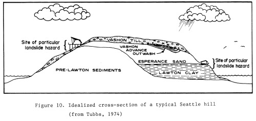
The layers ordered in this way because the silts are deposited at the bottom of the lakes created by the glacier blocking a river or faster moving body of water that builds up in an area. Then when the glacier moves forward it pushes the sands that were deposited in the faster moving water on top of the silt/clay layer. The till is still underneath the glacier and is moved on top of the sand layer and when the glacier recedes the till is deposited on the top layer. The Lawton clay is a layer that can be very dangerous in this area. Clay is impermeable to water and causes a build up of water on top of the layer, which can cause the layers of sand and rocks on top of it to slide off. Landslides are very common in this area during the wet winter because of this.
1. Vashon till
Mixed unsorted, boulders, rocks, sand, silt, and clay, deposited by the glacier.
2. Esperance Sand
Loose, yellow-tinted sand deposited by glacial meltwater and mountain streams.
3. Lawton Clay
Dark blue-grey clay and silt which accumulated at the base of a huge freshwater lake created by glacial meltwaters.
4. Kitsap Formation
Sediments that accumulated in lakes and streams before the last glacier pushed over the Puget Sound lowlands


 |
| Picture from Geologic Hazards in Seattle By Donald W. Tubbs and Thomas Dunne http://www.tubbs.com/geohaz77/geohaz77.htm |
For more information on the geology of Discovery Park see:
Puget Sound Under Ice on the Department of Ecology's Puget Sound Shorelines
No comments:
Post a Comment