
A. Park in the South Parking Lot off of Emerson St.
B. Walk around in the meadow that surrounds the parking lot and observe the restoration efforts that are happening here due to the disturbances. (1)
C. Head down the stairs to link up with the loop trail.
D. Look up on the slopes with ferns and other shrubs. Try to find mountain beaver holes. Be wary of stinging nettle if you wander off the trail. (2)
E. Continue up the loop trail. Look on the sides of the trail for mushrooms and other fungi. Look on tree bark for lichen. (3)
F. Continue along this trail deeper into the forest .
G. Note all the different kinds of shrubs and trees along your way. Stop and investigate and see if you can identify any. Also keep an eye out for wildflowers, too. (4)
H. As you go back towards the south parking lot stop and be quiet. Look for any birds that peek their heads out. Listen for bird songs! (5)
I. Next, head past the south parking lot on the loop trail. As you walk along look for signs that say viewpoint. Follow the signs to the first viewpoint. Take some time to enjoy the sites. As you continue along the walk you will get progressively closer to the water. (6)
J. Check out the second viewpoint located on top of the south bluffs. (7)
K. Merge onto the South Beach Trail and continue to the beach. (Beware the way back up the stairs can be quite a hike.)
L. Once you reach the beach look up at the bluffs. (8)
M. Walk towards the lighthouse and look for invertebrates (9)
N. Check out the West Point Lighthouse (10)
O. Return the way you came back to the parking lot. Make a stop at the historic district. (11)
P. Drive to the North Parking Lot along Texas Way.
Q. Park in the North Parking Lot
R. Check out the little pond just off of the parking lot. This is a great place to observe ecological interactions. (12)
S. Go to the paved trail and find the viewpoint off of it (13)
T. Then go look at the Daybreak Star Indian Cultural Center, a part of Discovery Park's rich history. (14)
U. Find your way back safely!
Station 1: Disturbance


Just north to the South Parking lot, there is entire area that has been, and is in the process of being, re-planted that represents a very recent disturbance site at the park. Bark covers the ground and lots of little stumps cover the area surrounded by newly planted trees, shrubs, and flowers. In what looks like a meadow, you can just barely see the trees peeking over the tall grass and further north you can see little pools of the Broadleaf Lupine flower along with other species of plants. There are different levels of restoration that have been occurring in this area as seen by some trees not nearly 3 feet tall and other that have reached almost 6 feet tall. The bark under the taller trees is a lot more hidden and not immediately visible whereas it is very visible in the more recently planted areas. There are also piles of bark near the parking lot and garbage cans in the area that represent the ongoing process of restoration. Most of what is planted is smaller shrubs and flowers rather than trees which shows how the disturbed site will most likely succeed first with plants that love open area and sunlight. Eventually, this area will become dominated by some of the common trees in the area and extend the forest.
Station 2: Animal Behavior
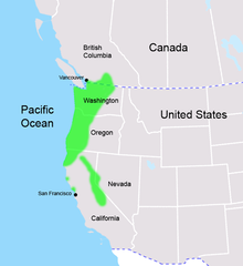
Mountain Beavers

Mountain beavers are a member of the family Rodentia. They can be found on moist, forested slopes which makes Discovery Park the perfect place to find them. They are herbivores and build their nests underground under thick vegetation.We have yet to see a mountain beaver ourselves, but this is probably due to the fact that they live very secretive lives mostly underground in their dens. They are also mostly nocturnal, but are sometimes active during the day. We have however seen a hole that we believe to be a mountain beaver hole. These holes are not simply holes, they are extensive burrow systems with many compartments designated for certain activities. Burrow systems can have 10 or more exits and special compartments.
"Food items include all above and below-ground parts of ferns, salal, nettles, fireweed, bleeding heart, salmonberry, brambles, dogwoods, vine maples, willows, alders, and conifers. Mountain beavers also eat rhododendrons and other ornamental perennials, shrubs, and trees." (wdfw.wa.gov) Mountain Beavers must drink 1/3 of their body weight in water every day due to their primitive, inefficient kidneys.
It is very difficult to see a Mountain Beaver, but there are some ways in which you can identify their presence without actually seeing them.
-Look for active burrow systems: the holes will not have spider webs on them, there will be newly excavated soil, and the tunnel floor can look worn
- Look for feeding sites: haystacks of cut vegetation may be around the burrow entrance
-Look for tracks (pictured below)
Information provided by Mountain Beavers see: Paws' section on Wildlife and the page on Mountain Beavers
http://www.paws.org/mountain-beavers.html
and
Washington Department of Fish and Wildlife's Page on Mountain Beavers
http://wdfw.wa.gov/living/mtn_beavers.html
Mountain Beavers
 |
| The Mountain Beaver hole we found |
 |
| Distribution of Mountain Beavers |
Mountain beavers are a member of the family Rodentia. They can be found on moist, forested slopes which makes Discovery Park the perfect place to find them. They are herbivores and build their nests underground under thick vegetation.We have yet to see a mountain beaver ourselves, but this is probably due to the fact that they live very secretive lives mostly underground in their dens. They are also mostly nocturnal, but are sometimes active during the day. We have however seen a hole that we believe to be a mountain beaver hole. These holes are not simply holes, they are extensive burrow systems with many compartments designated for certain activities. Burrow systems can have 10 or more exits and special compartments.
"Food items include all above and below-ground parts of ferns, salal, nettles, fireweed, bleeding heart, salmonberry, brambles, dogwoods, vine maples, willows, alders, and conifers. Mountain beavers also eat rhododendrons and other ornamental perennials, shrubs, and trees." (wdfw.wa.gov) Mountain Beavers must drink 1/3 of their body weight in water every day due to their primitive, inefficient kidneys.
It is very difficult to see a Mountain Beaver, but there are some ways in which you can identify their presence without actually seeing them.
-Look for active burrow systems: the holes will not have spider webs on them, there will be newly excavated soil, and the tunnel floor can look worn
- Look for feeding sites: haystacks of cut vegetation may be around the burrow entrance
-Look for tracks (pictured below)
 |
| Mountain Beaver Tracks |
 |
| Mountain Beaver Burrow System From the Washington Department of Fish and Wildlife |
Information provided by Mountain Beavers see: Paws' section on Wildlife and the page on Mountain Beavers
http://www.paws.org/mountain-beavers.html
and
Washington Department of Fish and Wildlife's Page on Mountain Beavers
http://wdfw.wa.gov/living/mtn_beavers.html
Station 3: Fungi


 |
| Foliose lichen |
 |
| Artist's Conk |
 |
| Fruticose lichen |
 |
| Genus Agrocybe |
There is a wide diversity of Lichen found on the trunks of trees throughout the forest. You can find good examples of all three different kinds of lichen: crustose, foliose, and fruticose. Mainly, you will see them on all the Bigleaf Maple trees that are all around the park. The crustose lichen looks like white, crusty spots on the tree trunks whereas the foliose lichen is much more leaf-like in appearance. Fruticose lichen is most often associated with their hairy appearance in old forests, but they have many branches and extensions which give them the bushy appearance. Mushrooms, on the other hand, are a bit harder to find. The types of mushrooms that you see the most of are ones that are usually associated with the growing on or near trees/bark. Artist's Conk can be found on many different trunks, both standing and fallen. Sometimes you can also find Turkey Tail, which is not to be confused with Artist's Conk, but both are polypores that grow on the trunks of trees. Mushrooms in the genus Agrocybe can be found in many clusters at the disturbance sites growing on the bark and near the old stumps. Other than in these two areas, most of the fungi that is to be found is on the sides of the trails (another disturbance site) and/or deep in the forest where there is a lot of moisture.
Station 4: Plants
These are the plants that are not only abundant in Discovery Park, but are abundant in the Puget Sound area. Upon walking through the trails of the park you should find all of these in many different areas.
Red-Flowering Currant (Ribes sanguineum)
 |
| Red flowers on the Red-Flowering Currant |
 |
| Leaf and stem of Red-Flowering Currant |
 |
| Field drawing of Red-Flowering Currant |
Deciduous shrub that stands erect on the forest floor. Leaves are 5-lobed, double-toothed, and have a soft texture due to fine hairs on the leaf. The stem is woody and also has fine hairs on it which make it soft to the touch. Flowers have 5 sepals, 5 petals, 5 stamens, and 1 carpel. They have a tubular shape, are arranged conically around the petiole in an alternate fashion. Leaves and flowers branch out in a palmate structure. In the spring, this plant can mainly be identified by its red-pink flowers. It also has a black berry that is not present at this time. You can find it in areas that are not heavily covered by other trees and shrubs so it has some sunlight and usually in lowland - low mountain areas.
Thimbleberry (Rubus parviflorus)
 |
| Field drawing Thimbleberry leaf |
 |
| Thimbleberry leaf |
This deciduous shrub stand erect off the forest floor and has 5-lobed leaves that are in a palmate structure and are double-toothed. The leaves have fine hairs on them that make them very soft. It often is referred to as "nature's toilet paper" to any backpacker or camper spending a few days in the woods. This plant can mainly be identified from touch and its leaves have a lighter green color. It has red raspberries that when plucked off, the receptacle stays on the plant which gives it the "thimble" appearance. White flowers also bloom on it. It has a woody stem and can be found in open places in the forest that have lots of sunlight.
Salmonberry (Rubus spectabilis)
 |
| Leaf of Salmonberry |
 |
| Thorns on Salmonberry stem |
 |
| Flower of Slamonberry |
 |
| Field drawing of Salmonberry |
Deciduous shrub that can stand pretty tall off the forest floor, much taller than me. It comes from the rose family so it has protruding thorns on its stem and small hair-like thorns under its leaves. The leaves are serrated and 3-compound. It has a magenta flower that has 5 sepals, 5 petals, lots of stamens, and a carpel that is covered by the stamens of the plant. There are quite a few insects that like to explore inside the flower, so don't get too personal with the flower. The plant needs lots of moisture so it is usually found in wet areas next to small creeks in the lowland - low mountain areas.
Dull Oregon Grape (Mahonia nervosa)
 |
| Field drawing of Dull Oregon Grape |
 |
| Dull Oregon Grape |
Not to be confused with the Tall Oregon Grape (Mahonia aquifolium), this shrub stands erect closer to the forest floor than some other shrubs in the Pacific Northwest. The leaves are pinnately compound, toothed, and have a dull green color with even a little brownish color on them. Their leaf vein is not as pronounced as seen in the Tall Oregon Grape which is one way you can differentiate between the two. The leaves also look similar to that of a Holly plant and are smooth/leathery to touch. Mainly identified by the yellow flowers that are clustered at the top of the shrub. Can be found in open areas with sunlight and around other trees and shrubs in the area.
Indian Plum (Omelaria cerasiformis)
 |
| Branch of Indian Plum |
.JPG) |
| Field drawing of leaf of Indian Plum |
This broadleaf deciduous shrub can grow to decently tall lengths, well above my height. The leaves are simple and grow in a palmate structure in bundles. At this time in the season, this shrub has neither its flowers or its berries which makes it difficult to identify. However, there is a distinct smell similar to that of cucumbers that the leaves of the plant give off when crushed which can be a good indicator. This shrub is usually found in wetter environments next to creeks or streams where it has access to sunlight.
Western Red Cedar (Thuja plicata)
 |
| Western Red Cedar |
 |
| Field drawing of Western Red Cedar |
Evergreen conifer tree that grows to stand pretty tall. Branches are droopy and woody with scaly leaves placed alternately on the branch. The trunk of the tree is fibrous, has bark that can be easily peeled off, and gives off a sort of reddish hue. Can mainly be identified by its scaly leaves that come off the tree in a spray-like fashion. During pollination, the tips of the tree turn a reddish color and cones grow all over the tree. The cones grow erect on the tree in clusters and also have a scale-like appearance. Can be found all around the low-mid forests of the Pacific Northwest in rather densely packed areas of growth.
Bigleaf Maple (Acer macrophyllum)
 |
| Leaf of Bigleaf Maple |
 |
| Opposite structure of leaves |
 |
| Flowers of Bigleaf Maple |
 |
| Field drawing of Bigleaf maple |
In the spring, this this deciduous broadleaf tree can be easily identified by its drooping flowers that eventually drop off onto the ground as new leaves begin to grow back onto the tree. Can stand very tall and grow very thick trunks. Leaves are 5-lobed and big which is the easiest way to distinguish it from a Vine Maple or Douglas Maple. The leaves come off in an opposite structure and when growing are a light green color. The edges of the leaves are serrated and there is an intricate venous structure in the leaf. The bark on the trunk is ridged and a lighter brown color-almost dark gray color.
Douglas-fir (Pseudotsuga menziesii)
 |
| Douglas-fir branch and cone |
.JPG) |
| Field drawing of Douglas-fir cone |
This evergreen conifer can be found in recently disturbed areas as it is a colonizer in the succession of the area, built to be able to adapt to harsh environments. One of the main characteristics that separates the Douglas-fir is the conical distribution of the needles on the branches. The needles have round tips and are flat. The cones are brown and scaly that has floppy protrusions that look like "rat butts" (3 pointed tips). It has thick bark that protects the tree from fire. These trees can be found in a wide abundance of forests except at high elevations.
Station 5: Birds
Discovery park is known for its abundance of species of birds. 270 species have been found in the park.
These are the species of birds that we have observed at our site over the quarter:
Song Sparrow
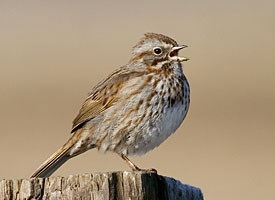
The Song Sparrow we encountered was quite the boisterous one. He sat atop a tree and was not shy at all about calling out his distinct bird call. When he was doing this it almost looked like he was going to explode he was putting so much effort into every call. He didn’t seem to mind us being there let alone us staring at him for a good ten minutes. He was quite a sight to see.
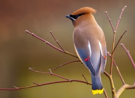
Cedar Wax Wing
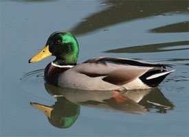
Mallard
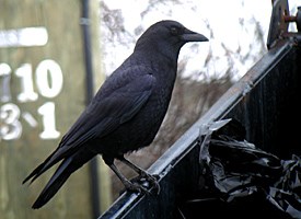
American Crow
American Robin
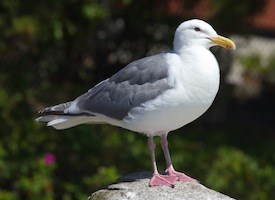
Glaucous-winged Seagull
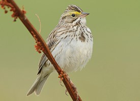
Savannah Sparrow
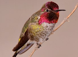
Anna's Hummingbird
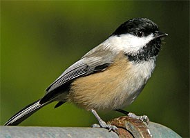
Black Capped Chickadee
White Crowned Sparrow
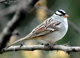
The White-Crowned Sparrows sure let us know of their presence in Discovery Park. Every time we saw a little white and black head on a little brown body we could hear the bird announcing “I am a White-Crowned Sparrow” with its call.
American Goldfinch

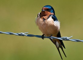
Barn Swallow
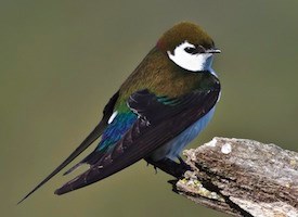
Violet-green Swallow
All pictures from allaboutbirds.org!
Below is a link that shows these bird species and many others that we haven't see and their level of abundance by season. This should help you to go on our walking tour any time of year.
http://www.seattle.gov/parks/environment/DiscoveryParkBirds.pdf
Discovery park is known for its abundance of species of birds. 270 species have been found in the park.
These are the species of birds that we have observed at our site over the quarter:
Song Sparrow
The Song Sparrow we encountered was quite the boisterous one. He sat atop a tree and was not shy at all about calling out his distinct bird call. When he was doing this it almost looked like he was going to explode he was putting so much effort into every call. He didn’t seem to mind us being there let alone us staring at him for a good ten minutes. He was quite a sight to see.
Cedar Wax Wing
Our encounter with the Cedar Waxwing was quite special. We
were on top of the South Bluff and a pair of rather large birds whizzed past
us. I whipped my binoculars up trying to identify what exactly it was, but I
did not recognize it. We wrote down the distinct characteristics about the bird
that we could use later to look up. A tan “Mohawk” (actually a tuft), black
surrounding the eyes, and a body that faded from the tan of the Mohawk to a
greyish color. I did not see the most distinct characteristic of the Waxwing
which gives it its name: colorful and waxy feathers on the wings.
Mallard
American Crow
American Robin
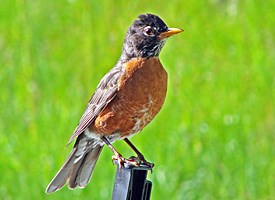
The American Robin is a joyful sight to see with its
cheerful call and its strange way of rushing across the ground and abruptly
stopping to pick a worm out of the ground. Everywhere you go in Discovery Park
you can probably find a Robin or hear its call “cheer-up, cheerily” somewhere
off in the distance.
Glaucous-winged Seagull
Savannah Sparrow
Anna's Hummingbird
Seeing the Anna’s Hummingbird was one of the most exciting
parts of our time at Discovery Park. When we saw him he was doing the
Hummingbird mating dance. He flew up really high and then dropped down towards
the ground in what almost seemed like a death defying stunt. When he finally
pulled up as to not hit the ground you could hear a loud chirp of his wings.
Black Capped Chickadee
White Crowned Sparrow
The White-Crowned Sparrows sure let us know of their presence in Discovery Park. Every time we saw a little white and black head on a little brown body we could hear the bird announcing “I am a White-Crowned Sparrow” with its call.
American Goldfinch
Barn Swallow
Violet-green Swallow
All pictures from allaboutbirds.org!
Below is a link that shows these bird species and many others that we haven't see and their level of abundance by season. This should help you to go on our walking tour any time of year.
http://www.seattle.gov/parks/environment/DiscoveryParkBirds.pdf
Station 6: View Point off of Loop Trail


As you start to walk towards the South Beach, you will reach your first viewpoint of the water. It is a short trip off of the Loop Trail and is definitely worth the time to take a little break and enjoy the scenery. It overlooks the South Meadow and gives a great site of all the boats in the water and beautiful natural sights that the park has to offer. There are picnic tables here at this stop, so it is a great place to take the kids and have a snack or have a water break. Also, there is a cut grass area that host lots of games like frisbee and/or also serves as a nice area to have a picnic. This is a great place to look for birds out in the meadow! Quite a few White-crowned Sparrows makes appearances around this area and even though you may not be able to spot them, you will definitely be able to hear them. Up above, you can see lots of swallows, including the Violet-green Swallow and the Barn Swallow, chasing after insects. There are other viewpoints closer to the water along the trail, but this one gives the best view of the whole south side of the park.
Station 7: Viewpoint on top of bluff


The second viewpoint that you come across on your way to South Beach places you right on top of the bluffs and much closer to the water than the previous viewpoint. It is right next to the sandy area which is a great play place for children. There are a few signs that tell you about some of the species in the area and gives a little background information on the geographical significance of the bluffs. This is a great place to learn about some of the natural history of the park while enjoying another great scenic view of the water. There are quite a few seats and benches so this can be another good break point before you make the downhill trek to the beach. Try to look for some birds as this is a good area for spotting a variety as the South Meadow sits behind you and the beach in front of you. A few Song Sparrows and Savannah Sparrows can be heard around here and also a lot of Gulls. There is also the potential to see the Eagles that have been known to make appearances at the park. The grassy areas once again make a great place for picnics.
Station 8: Geology
The bluffs of Discovery Park on the South Beach are a perfect example of the layers left behind by the Vashon Ice sheet that covered the Puget Sound in the last ice age around 15,000 years ago. When you look at these bluffs you can clearly see the lines that define each of the layers. The top layer in the picture below was rocks and other materials that were dragged underneath the glacier as it was moving forward during the ice age and were deposited as the glacier receded. The second layer was medium sized bits of sand and rock that were deposited by glacial meltwater and mountain streams that were faster moving compared to the lakes created by glacial meltwaters. Because the water was faster moving only the larger pieces of sand could be deposited, the silts were too small to be deposited until they reached slower moving water.
The layers ordered in this way because the silts are deposited at the bottom of the lakes created by the glacier blocking a river or faster moving body of water that builds up in an area. Then when the glacier moves forward it pushes the sands that were deposited in the faster moving water on top of the silt/clay layer. The till is still underneath the glacier and is moved on top of the sand layer and when the glacier recedes the till is deposited on the top layer. The Lawton clay is a layer that can be very dangerous in this area. Clay is impermeable to water and causes a build up of water on top of the layer, which can cause the layers of sand and rocks on top of it to slide off. Landslides are very common in this area during the wet winter because of this.
1. Vashon till
Mixed unsorted, boulders, rocks, sand, silt, and clay, deposited by the glacier.
2. Esperance Sand
Loose, yellow-tinted sand deposited by glacial meltwater and mountain streams.
3. Lawton Clay
Dark blue-grey clay and silt which accumulated at the base of a huge freshwater lake created by glacial meltwaters.
4. Kitsap Formation
Sediments that accumulated in lakes and streams before the last glacier pushed over the Puget Sound lowlands


Information provided by:
Puget Sound Under Ice on the Department of Ecology's Puget Sound Shorelines
http://www.ecy.wa.gov/programs/sea/pugetsound/tour/geology.html
The bluffs of Discovery Park on the South Beach are a perfect example of the layers left behind by the Vashon Ice sheet that covered the Puget Sound in the last ice age around 15,000 years ago. When you look at these bluffs you can clearly see the lines that define each of the layers. The top layer in the picture below was rocks and other materials that were dragged underneath the glacier as it was moving forward during the ice age and were deposited as the glacier receded. The second layer was medium sized bits of sand and rock that were deposited by glacial meltwater and mountain streams that were faster moving compared to the lakes created by glacial meltwaters. Because the water was faster moving only the larger pieces of sand could be deposited, the silts were too small to be deposited until they reached slower moving water.
The layers ordered in this way because the silts are deposited at the bottom of the lakes created by the glacier blocking a river or faster moving body of water that builds up in an area. Then when the glacier moves forward it pushes the sands that were deposited in the faster moving water on top of the silt/clay layer. The till is still underneath the glacier and is moved on top of the sand layer and when the glacier recedes the till is deposited on the top layer. The Lawton clay is a layer that can be very dangerous in this area. Clay is impermeable to water and causes a build up of water on top of the layer, which can cause the layers of sand and rocks on top of it to slide off. Landslides are very common in this area during the wet winter because of this.
1. Vashon till
Mixed unsorted, boulders, rocks, sand, silt, and clay, deposited by the glacier.
2. Esperance Sand
Loose, yellow-tinted sand deposited by glacial meltwater and mountain streams.
3. Lawton Clay
Dark blue-grey clay and silt which accumulated at the base of a huge freshwater lake created by glacial meltwaters.
4. Kitsap Formation
Sediments that accumulated in lakes and streams before the last glacier pushed over the Puget Sound lowlands

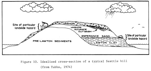 |
| Picture from Geologic Hazards in Seattle By Donald W. Tubbs and Thomas Dunne http://www.tubbs.com/geohaz77/geohaz77.htm |
Information provided by:
Puget Sound Under Ice on the Department of Ecology's Puget Sound Shorelines
http://www.ecy.wa.gov/programs/sea/pugetsound/tour/geology.html
Station 9: Invertebrates


When you first arrive on
the beach from the street access, you will see a collection of signs. One is
especially alarming. It reads “WARNING Toxic Shellfish”. None of the shellfish
from the Discovery Park beaches are to be eaten due to a paralytic toxin. This
toxin comes from a certain kind of algae. When the shellfish eat the algae they
have no choice but to ingest their toxins as well. These toxins stay inside the
shellfish for long periods of time. Normally the amount of toxins that are in
the clams, mussels, oysters, and scallops is not harmful at all. However a “bloom”
of algae can cause the toxins to get to a very dangerous level. Blooms are
caused by a combination of warm temperatures, sunlight, and nutrient-rich
waters. These conditions cause rapid algae reproduction.
When people think of
algae blooms, they often think of the red tides of algae, but this is not what
happens when the shellfish become toxic. The red tides are associated with a
bloom of algae that is not harmful to humans. This bloom that causes poisonous
shellfish can be caused by a bloom that cannot even be seen from the beaches.
A VERY IMPORTANT NOTE:
Cooking does not get rid of the toxin. It will kill the algae that produced the
toxin, but the toxin will remain and will still be very harmful.
Types of shellfish that
are particularly dangerous in this situation:
Mussels: They accumulate
toxins faster than any other shellfish
Varnish Clams: They
accumulate the highest levels of the toxin
Varnish Clams and Butter
Clams: Store the toxins for the longest amount of time
Information provided by:
Washington State
Department of Health’s page on Marine Biotoxins
Harmful Algae
Station 10: West Point Lighthouse

The lighthouse began operations on November 15, 1881. When the ship canal on
Lake Washington was built the lighthouse also served as a marker of the
entrance to the "liquid link between the Puget Sound and Lake Union and
Lake Washington"(Lighthousefriends.com). Over the years and through the
advancement of technology the mechanism that the lighthouse used to alert boats
has changed from a fog bell to a fog signal to a fog signal that was operated
by engines to automation in 1985. The lighthouse stayed manned until its
centennial in 1981because the keeper at the time made the request. He
celebrated the centennial by smashing a champagne bottle on the lighthouse.
The keepers of the lighthouse quite enjoyed their time there despite many
problems associated with the area. They were majorly isolated from other
people, but were provided a boathouse and a boat to row the seven miles to
Seattle. There also was quite a large mosquito problem to the point where they
had to wear nets around the house and the yard. The biggest problem of all was
the sewage that was being dumped around West Point everyday. It got so bad that
they could not even go on the North Beach due to the FEET of raw sewage that
had accumulated. This did not improve until the West Point Treatment Plant was
built in 1966.
Information provided by Lighthouse Friends
http://www.lighthousefriends.com/light.asp?ID=33
Information provided by Lighthouse Friends
http://www.lighthousefriends.com/light.asp?ID=33
Station 11: Land Use History

Originally, the land where Discovery Park now sits was an Army base called Fort Lawton. The base was developed in the 1890s and generally had very little use. Usually there was only one battalion there at one time. There were early calls for the fort to be made a park. In 1938, the US Army offered the fort to the City of Seattle for one dollar. However, the city declined the offer because they believed the cost of maintenance would be too expensive.
Then when World War II happened the fort became of great importance to the Army. "Up to 20,000 troops were staged there at one time, and a total of 1.1 million troops passed through the installation during and after the war. Some 1,150 German prisoners of war were housed there, and 5,000 Italian prisoners of war passed through on their way to confinement in Hawaii" (Seattle Parks and Recreation). Fort Lawton continued its important role with the Army during the Korean War. Many men were sent into duty from this fort.
After these wars, Fort Lawton's activity declined yet again. many bills were proposed for purchase of the land for a park, the United Indians of All Tribes claimed all lands that were surplus as their own. The city negotiated an agreement to lease them 17 acres for an Indian cultural center.
In 1972, the Fort Lawton (Discovery) Master Plan was submitted to the city. (Discovery Park was named after the HMS Discovery that was part of the first European exploratory voyage to the Puget Sound)
In 2005, the 70th Regional Support Command Headquarters would close. The park has now become a place of wonder for the City of Seattle even after years of fighting off people who wanted the land for other uses.
Information provided by:
Discovery Park History on the Seattle Parks and Recreation website
http://www.seattle.gov/parks/parkspaces/discoverypark/history.htm
The Discovery Park Story by Bob Kildall
https://docs.google.com/document/d/1ll2ByhOTfPoouLKtgw9UfBJ_trWOFEEi8kVJOBWFjhE/pub
Station 12: Ecological interaction at pond


There are lots of ecological interactions just waiting to be observed at any of the ponds in the park. Lots of these ponds are visited by ducks, particularly the Mallard. These pond ducks can feed on algae, insects, fish, worms, and other resources found in the pond. This is a great example of predation on many different kinds of species that reside at the pond. With such good resources, the ducks can then become competitive of the territory in the effort to retain as many of these resources as they can. Witnessing ducks quack at each other and chase each other away is not uncommon if a stranger duck comes to close to where one duck has chosen to feed for himself. There is also a sense of mutualism between a male and female ducks as you are almost always sure to find a male and female together whether they be on land, water, or in the air. Ponds are great examples of many other predations by many other species like frogs, toads, and fish that eat a lot of insects. Insects seem to have a high population density at and around ponds so this predation consequentially can help keep the insect abundance at lower levels than they have the potential to be. The grass at ponds also provide a great residence for many species and a hiding place from potential threats and/or predators.


There are lots of ecological interactions just waiting to be observed at any of the ponds in the park. Lots of these ponds are visited by ducks, particularly the Mallard. These pond ducks can feed on algae, insects, fish, worms, and other resources found in the pond. This is a great example of predation on many different kinds of species that reside at the pond. With such good resources, the ducks can then become competitive of the territory in the effort to retain as many of these resources as they can. Witnessing ducks quack at each other and chase each other away is not uncommon if a stranger duck comes to close to where one duck has chosen to feed for himself. There is also a sense of mutualism between a male and female ducks as you are almost always sure to find a male and female together whether they be on land, water, or in the air. Ponds are great examples of many other predations by many other species like frogs, toads, and fish that eat a lot of insects. Insects seem to have a high population density at and around ponds so this predation consequentially can help keep the insect abundance at lower levels than they have the potential to be. The grass at ponds also provide a great residence for many species and a hiding place from potential threats and/or predators.
Station 13: View Point off of Wolf Tree Nature Trail

Station 14: Daybreak Star Indian Cultural Center


In 1970 when Fort Lawton's acreage was declared as surplus, the United Indians of All Tribes organization declared that they deserved this land. They fought many political sanctions and argued with many leaders in order to obtain the land. Their group split to two sides, the ones who preferred to wait for the government to obtain the land and then receive it from them and the ones who wanted direct action.
The faction that wanted direct action was led by Bernie Whitebear (who the
street that the DSICC is located on is named after). They planned to peacefully
invade the base from both directions by scaling cliffs to get there. During the
invasion Jane Fonda was there and according to Whitebear this caused quite a
stir. her presence "captured the imagination of the world press. American
Indians were attacking active military forts along with one of the nation's
leading opponents of United States involvement in the Vietnam War." Her
presence transformed "an effort to secure a land base for urban
Indians" into "a bizarre, ready-for-prime-time, movie scenario,
complete with soldiers, modern-day Indians, and anti-war activists. Without
really appreciating it at the time, the Indian movement had achieved through
Jane Fonda's presence, a long-sought credibility which would not have been
possible otherwise." (Wikipedia)
The invasion did not stay non-violent as planned apparently due to the rough
handling of some of the invaders by military police.
After many months of campaigning and continued fighting the government
finally gave in. In November 1971, the United Indians of All Tribes were given
a 99 year lease on 20 acres in Discovery Park. In 1977 the facility opened. It
now is a meeting place for all tribes around the area of Seattle where Pow Wows
can be held. There is also a permanent art collection there that can be viewed.
Information provided by:
United Indians of All Tribes Foundation http://www.unitedindians.org/daybreak.html
and Wikipedia http://en.wikipedia.org/wiki/Daybreak_Star_Cultural_Center
Information provided by:
United Indians of All Tribes Foundation http://www.unitedindians.org/daybreak.html
and Wikipedia http://en.wikipedia.org/wiki/Daybreak_Star_Cultural_Center
No comments:
Post a Comment